
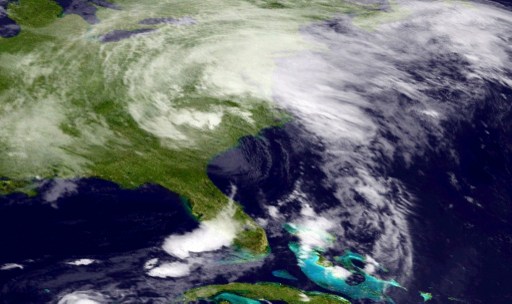
This National Oceanic and Atmospheric Administration (NOAA) GOES East Satellite image released June 7, 2013 shows Tropical Storm Andrea. Tropical storm Andrea dumped heavy rains on Florida Thursday and threatened to bring high winds and rough seas to much of the US East Coast after earlier tearing across western Cuba. At around 2140 GMT the first named storm of the Atlantic season made landfall in Dixie County, Florida, about 10 miles (16 kilometers) south of Steinhatchee, according to the Miami-based US National Hurricane Center. The storm — which packed maximum sustained winds of 65 miles per hour and was moving to the northeast at 17 miles per hour — could whip up tornadoes in central and southern Florida, the NHC said. AFP PHOTO / NOAA == RESTRICTED TO EDITORIAL USE / MANDATORY CREDIT: “AFP PHOTO / NOAA / NO MARKETING / NO ADVERTISING CAMPAIGNS / DISTRIBUTED AS A SERVICE TO CLIENTS ==